Unlock basin geometry insights with our multiclient datasets—produced using hybrid, self-supervised machine learning 3D projection from 2D seismic data.
From uncertainty to opportunity: transforming ultra-deepwater frontier exploration in the Lower Congo Basin, Angola
The abyssal plain and lower slope areas of the ultra-deepwater Lower Congo Basin, Angola represent a frontier exploration area with prospective Tertiary turbidite reservoirs as the primary exploration targets. This study applied ExploreCube™ rapid frontier intelligence, a proprietary AI-enabled 2D-to-3D workflow, to transform 4,065 km of reprocessed 2D seismic data into a seamless pseudo-3D volume covering more than 20,000 km². The resulting dataset enabled basin-scale interpretation, significantly improving the visualization and mapping of structural and stratigraphic features. This reduced key exploration uncertainties and enhanced the evaluation and ranking of prospects in this frontier basin.
Transforming Sparse 2D Seismic Data into Basin-Scale 3D Intelligence
The ultra-deepwater Lower Congo Basin in offshore Angola remains one of the most attractive frontier exploration provinces where Tertiary Congo River turbidite sands, proven in adjacent deepwater blocks 31 and 32, are interpreted to extend into Blocks 46, 47, and 48, and the abyssal plain. Although still a frontier play, the area is considered highly prospective due to its thick sedimentary section and proven nearby petroleum systems.
The large frontier acreage within the abyssal plain is constrained by sparse 2D seismic coverage, making regional play evaluation, stratigraphic interpretation, and prospect identification challenging. Traditional interpretation workflows rely heavily on discrete 2D lines, limiting the ability to visualize basin-scale depositional systems and assess reservoir continuity with confidence.
This study demonstrates how an integrated geoscience and AI workflow transformed sparse regional 2D seismic data into a geologically consistent 3D visualization environment. Using ExploreCube intelligence, 4,065 km of Kirchhoff pre-stack depth migrated (KPSDM) 2D seismic data, comprising 36 dip lines and 13 strike lines acquired by SLB in 1998 and reprocessed in 2015, were converted into a high-resolution volumetric representation covering over 20,000 km² in the Lower Congo Basin, enabling full-volume interpretation and attribute analysis.
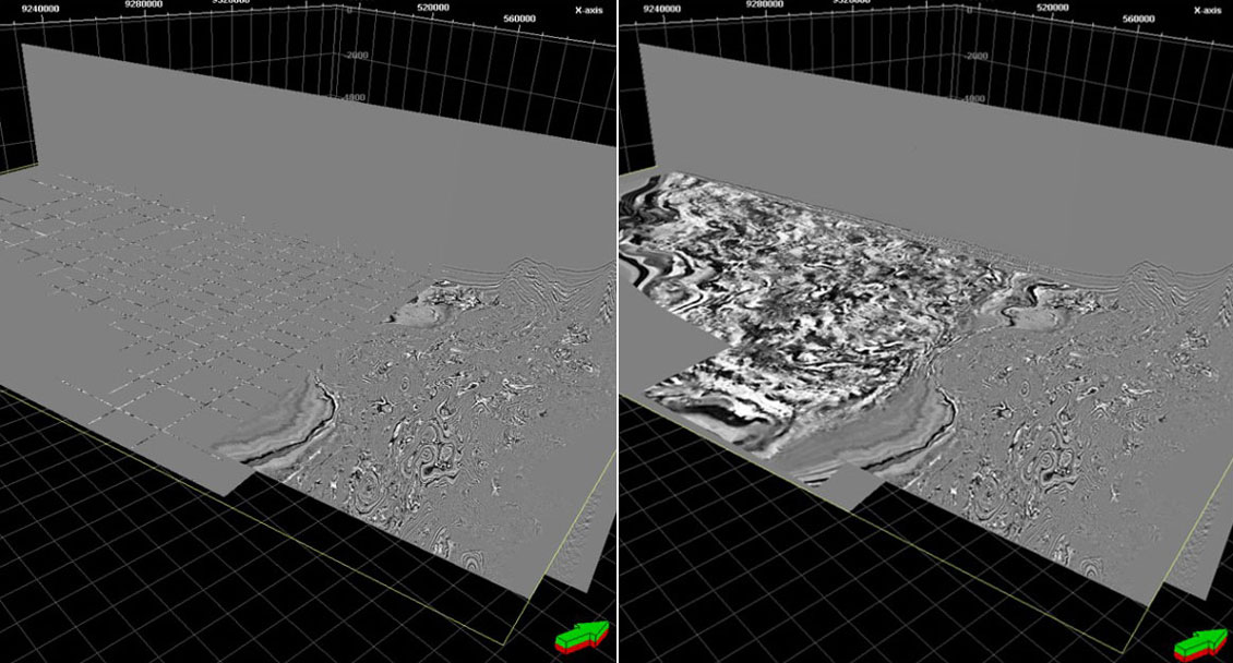
The workflow integrated 2D seismic data with regional structural frameworks to generate a geologically consistent 3D representation of the basin. First, amplitude balancing was applied to ensure consistency across the different seismic vintages. Reference proxy models were then constructed to capture the basin’s structural framework, based on key regional formations and depositional sequences derived from the available seismic, existing geological knowledge, and literature. Training labels were used in the machine learning step to ensure the model accurately represented the existing seismic character of the basin. These labels were constructed based on the existing 2D seismic and randomly sampled locations with the existing seismic trace response to guide the initial neural network training and inference. Through an iterative, self-supervised deep-learning process, volumetric images were progressively refined, converging toward the known seismic inputs while creating a continuous and geologically realistic 3D image, Figure 1.
Accelerating Prospect Identification with ExploreCube Intelligence
The resulting ExploreCube intelligence volume provided a robust framework for seismic interpretation and regional prospectivity assessment. Interpretation of eight key horizons established the tectonostratigraphic framework for basin analysis. This allowed interpreters to visualize structural and stratigraphic relationships, beyond the limitations of individual 2D seismic lines, and facilitates basin-scale screening and rapid identification of exploration opportunities.
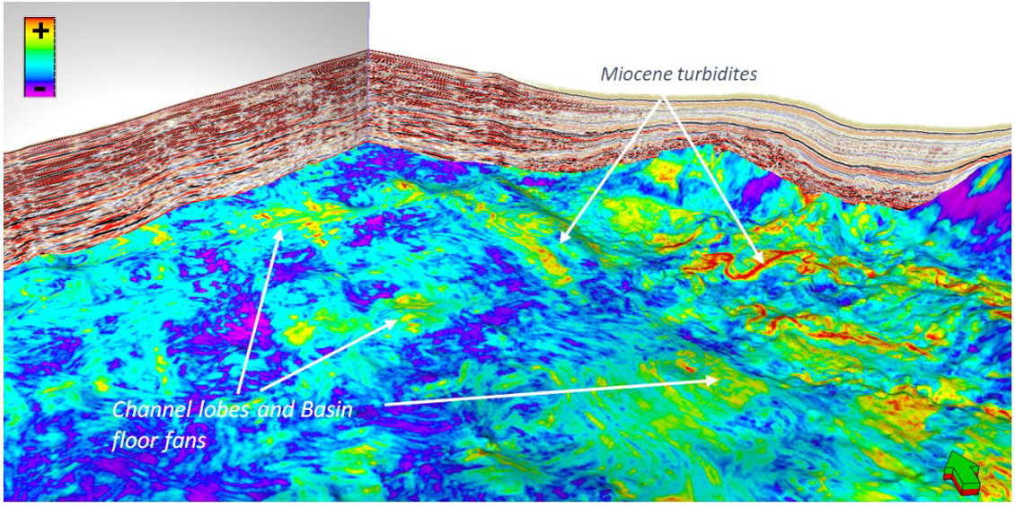
The team achieved a faster turnaround in the exploration workflow, by utilizing 3D interpretation functionality and volume rendering. The seamless merge between 2D and 3D data improved attribute mapping, revealing extensive Miocene and Oligocene deepwater turbidite systems extending from the slope into the abyssal plain.
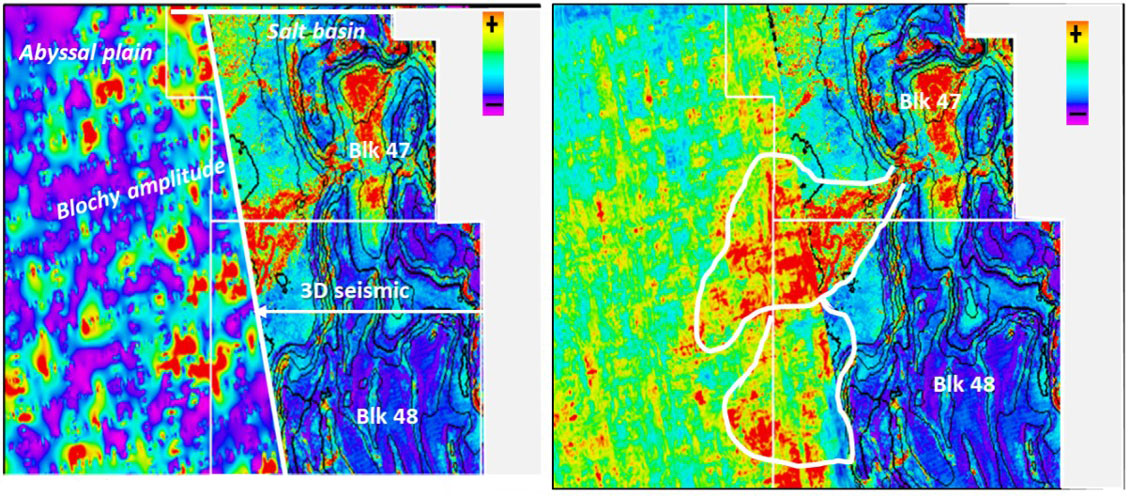
Enhanced imaging of channel complexes, basin-floor fans, and turbidite lobes provided evidence for laterally continuous reservoir fairways that were difficult to recognize using conventional 2D interpretation alone. Figure 2 illustrates how advanced seismic attribute extraction can transform a patchy, difficult-to-interpret amplitude response into a well-defined channel-lobe complex, improving confidence in reservoir and depositional system mapping across the block boundaries.
The volumetric approach also improved characterization of large structural closures associated with salt tectonics, enabling more robust assessment of trap integrity and reservoir distribution.
Overall, the study highlights how AI-enabled 2D-to-3D technologies can significantly accelerate frontier basin evaluation, improve subsurface understanding, and reduce exploration uncertainty. By enabling interpreters to render the data in different directions the workflow helped them to “see beyond 2D,”. The approach provides a powerful framework for high-grading acreage, identifying new play fairways, and supporting exploration decision-making in data-constrained frontier basins such as those in offshore Angola.
Arbitrary line from 3D ExploreCube intelligence volume