North America Land
Multiclient data library
Illuminate the subsurface with 2D and 3D seismic data, modern WAZ, and well log data.
Using ExploreCube™ rapid frontier intelligence—an advanced AI-powered process for frontier exploration—we deliver multiclient datasets that combine regional 2D seismic data with prior information, to generate detailed 3D subsurface images. At the core of ExploreCube intelligence is a deep learning framework that excels in handling complex nonlinear optimization. Unlike traditional methods, it operates without relying on pre-designed kernels, offering unmatched flexibility to incorporate a wide range of a priori subsurface information from diverse sources, so you receive the most comprehensive multiclient datasets possible.
The structural insights extracted with ExploreCube intelligence from regional 2D seismic images are used to iteratively construct evolving 3D image volumes. This process is powered by self-supervised learning, augmented features, and advanced deep learning networks, ensuring highly accurate and adaptive subsurface visualization.
ExploreCube intelligence bridges the gap between sparse 2D data and 3D seismic imaging. By using existing 2D vintages as inputs it constructs regional 3D images, that provide seamless coverage of full basins or margins. These projected images are used to extract cost-effective, volumetric insights, that improve regional subsurface understanding in areas where only 2D seismic data is available.
Leveraging a hybrid, AI-driven projection process, ExploreCube intelligence can handle irregular and sparse 2D vintage datasets with ease. It fully integrates existing 2D seismic information into its 3D projections, enabling the extraction of accurate and actionable volumetric insights even in data-limited regions.
ExploreCube intelligence aims to accelerate new frontier basin or margin understanding, where only 2D seismic data is available.
Go beyond incremental 2D seismic understanding
Transform regional exploration by moving from traditional 2D seismic analysis to comprehensive 3D basin insights. By generating regional 3D volumes from measured 2D vintages, ExploreCube intelligence unlocks the use of interpretable spatial attributes that are typically exclusive to 3D seismic imaging.
De-risk exploration decisions
ExploreCube intelligence helps reduce uncertainty and increase confidence in frontier exploration by providing projected 3D images that enhance decision-making before committing to significant exploration investments. Its approach enables volumetric rendering and multi-spectral decomposition—capabilities that are impossible to achieve with 2D seismic vintages alone.
Volumetric attributes, derived from 3D projections produced by ExploreCube intelligence, aid in the delineation of potential areas of interest in frontier environments. These insights are invaluable for planning and defining future 3D seismic programs, ensuring a more targeted and cost-effective exploration strategy.
ExploreCube intelligence fully integrates existing 2D seismic subsurface images into its final 3D projections. This streamlined process eliminates the need to switch between multiple 2D vintages, significantly improving data screening efficiency.
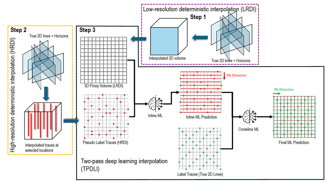
ExploreCube intelligence is specifically designed to handle ultra-sparse and heterogeneous 2D vintages, transforming them into 3D projections. The workflow leverages structural and deterministic information extracted from 2D seismic data and to train and execute a multidirectional learning and 3D projection process.
The first two steps focus on creating training labels for the final step. These labels are used as in a recursive and self-supervised training process, to construct the final 3D projection. The deep learning model is trained along orthogonal directions, using the constructed labels and the input 2D seismic data. The result is a contiguous and detailed 3D projected image, that not only captures the regional structure but also honors the existing measured seismic data used in the process.
The maximum spacing between 2D seismic lines that ExploreCube Intelligence can handle depends on several factors, including the amount of available data, and the availability of prior information. A balance must be struck between these elements to ensure optimal performance. When sufficient prior information is available to build meaningful and consolidated labels, ExploreCube intelligence can use this to construct a 3D volume. The resulting projection will be naturally biased towards the prior information; however it will still exhibit a realistic seismic character.
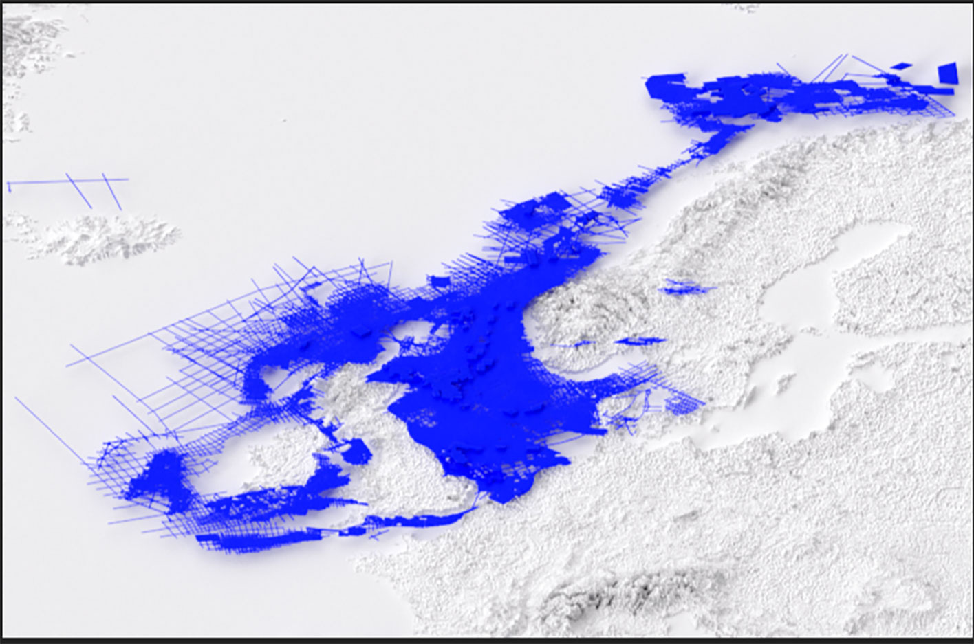
In previous cases, ExploreCube intelligence has successfully provided consistent projections in areas ranging from a space of 5 km x 10 km (dip x strike) up to 20 km x 20 km over the outboard area.
ExploreCube intelligence can handle somewhat variable line spacing, even when azimuthal directions are irregular or nearly random. In such cases, information from denser areas can be “borrowed” to improve projections for sparser regions, providing they fall within the same machine learning (ML)-reconstruction spatial domain. This approach can be more effective than a project with sparse data that has a regular 2D seismic line distribution.
ExploreCube intelligence multiclient datasets are licensed products in the multiclient data library.