Unlocking hydrocarbon potential in the Brazil Equatorial Margin by using pseudo-3D seismic volume from recent 2D reimaging | SLB

Unlocking hydrocarbon potential in the Brazil Equatorial Margin with pseudo-3D seismic volume from recent 2D reimaging

Bridging the gap between 2D and 3D seismic for exploration in offshore Brazil

minus
Brazil, South America, Offshore

A multidirectional learning algorithm was used to convert reprocessed 2D seismic data into pseudo-3D seismic volumes, covering approximately 260,000 km² of the Brazilian Equatorial Margin from the Foz do Amazonas to the Ceará basins. These continuous seismic images streamline exploration by enabling faster data screening and enhanced identification of stratigraphic plays, aiding in de-risking early-stage investment decisions in this frontier region. Visualization techniques like volume trimming, co-rendering, and spectral decomposition are instrumental in the delineation of key seismic features, critical for identifying exploration opportunities.

Maximizing 2D seismic value

The Brazil Equatorial Margin is predominantly covered by 2D seismic data with grid spacing ranging from 5 km x 5 km to 20 km x 20 km, and only sparse 3D seismic data, primarily in shallow-water and upper-slope areas.

This project aimed to maximize the value of available 2D imaging by employing a hybrid approach, that combines deterministic interpolation, deep learning, and geological priors to generate dense pseudo-3D seismic volumes—fully honoring the 2D seismic lines used as input to the workflow.

Having a regionally interpretable pseudo-3D volume, instead of working with multiple 2D seismic vintages, reduces the challenge of assessing hydrocarbon prospectivity in the immense and complex Brazil Equatorial Margin frontier.

These pseudo-3D volumes enable accelerated regional interpretation, by employing a hybrid approach that combines deterministic interpolation, deep learning, and geological priors to generate dense pseudo-3D seismic volumes,

While not a substitute for 3D seismic acquisition, this 2D-to-3D image conversion bridges the gap between 2D and 3D seismic data, facilitating efficient regional screening and comparative analysis across the Brazil Equatorial Margin frontier. This approach helps identify areas of interest, reducing exploration risks and supporting future investment decisions.

Enhanced seismic imaging for confident exploration decisions

The reprocessed 2D seismic dataset, completed in early 2024, includes 382 2D lines spanning over 67,000 linear kilometers, and provides comprehensive seismic coverage from Foz do Amazonas to Ceará basin (Figure 1):

map - EXD Multiclient Library - North Brazil
Figure 1: Map showing the extension of the 2D re-imaging program done in the BEM. More than 67,000 linear kilometers of 2D seismic data were included, from the Foz do Amazonas basin to the Ceará basin.

The reprocessing workflow, starting from field tapes, applied robust broadband signal processing techniques, including deghosting and multiple attenuation, as well as a pseudo-3D velocity model refined through five tomographic iterations and 2D full-waveform inversion (FWI) in the last stage. Geophysically, this reprocessed 2D data was matched in terms of phase, frequency, and amplitude across multiple surveys. From the geological side, the resulting seismic images show significant enhancement in definition and resolution at both deep and shallow intervals, enabling more confident structural and stratigraphic interpretation.

To advance regional geological understanding, the enhanced 2D seismic data, was used with horizon interpretations well calibrations to generate pseudo-3D seismic images using deterministic and machine-learning (ML) approaches (Figure 2A): This transformation enables the application of seismic interpretation tools such as volume rendering, geobody extraction, and multi-attribute overlay.

map - EXD Multiclient Library - North Brazil
Figure 2: A) Pseudo-3D image volumes cover four Brazil Equatorial basins: Foz do Amazonas, Pará-Maranhão, Barreirinhas and Ceará. Examples of seismic attribute visualization performed in the Foz PAMA Barr pseudo-3D cube at regional scale are shown in B) Foz do Amazonas, C) Pará-Maranhão and D) Barreirinhas basins.

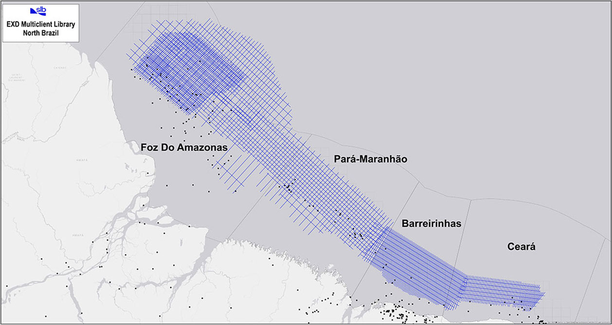
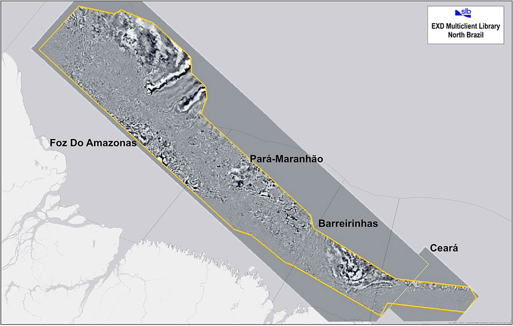
The resulting pseudo-3D volumes facilitate documentation of diverse play types in key basins like Foz do Amazonas, Pará-Maranhão, Barreirinhas, and Ceará, previously explored primarily for shallow-water structural traps.

In the complex tectonic framework of the Brazil Equatorial Margin basins, structural exploration opportunities remain relevant and can be identified both in the passive margin and syn-rift intervals. In the passive margin sequence, structural plays are mainly related to gravitational tectonics, which produced listric and toe-thrust faults. In the syn-rift sequence, structural plays are tilted blocks and structural highs are associated with normal faults, generated during the rifting phase.

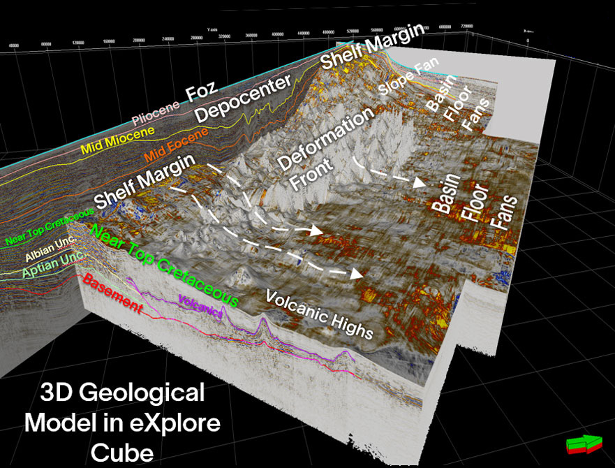
However, the most attractive opportunities are related to stratigraphic plays. These would be better documented with a contiguous 3D volume rather than the available multi-2D surveys. Figure 2B: shows a 3D geomorphological view of the Foz do Amazonas basin after applying a seismic cropping on the pseudo-3D volume, at the level of the Near Top Cretaceous surface. The inboard of the Foz do Amazonas shelf margin is interrupted by the Foz depocenter, which is highly deformed by a gravitational collapse system, producing a contractional domain with a deformation front towards the central part of the basin. In the outboard of Foz do Amazonas, seismic amplitude anomalies stand out and could be interpreted as a potential stratigraphic play type involving basin floor fans.

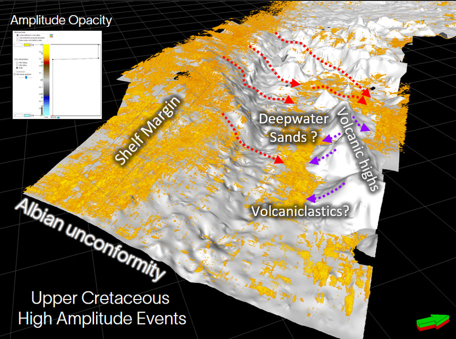
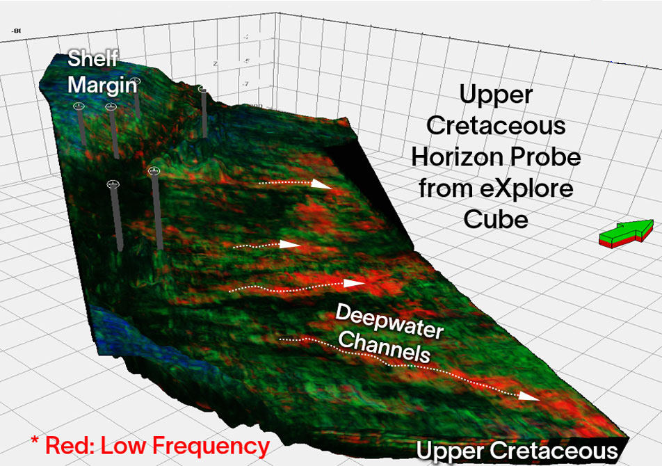
In the Pará-Maranhão basin, the opacity technique in the pseudo-3D cube was used to isolate high-amplitude anomalies in the Upper Cretaceous (Figure 2C): Some of these anomalies could present exploration targets, as they may be deepwater sandstones terminating against volcanic highs. In the Barreirinhas basin, 3D general spectral decomposition and color blending have successfully highlighted low-frequency features in the Upper Cretaceous that could suggest deepwater channels with basin floor fans (Figure 2D):

The pseudo-3D volume simplifies the challenges of working with multiple 2D seismic vintages and accelerates regional exploration screening by enabling the creation of seismic attribute volumes at play and basin scales. For the Brazil Equatorial Margin, where deepwater stratigraphic plays hold significant promise, these contiguous 3D images from a pseudo-3D volume can provide a valuable tool for early exploration assessments and the identification of high-potential areas.

Related resources

Products Used