Sri Lanka ExploreCube™ rapid frontier intelligence: AI-powered insight for smarter decisions | SLB

Sri Lanka ExploreCube™ rapid frontier intelligence: AI-powered insight for smarter decisions

Sri Lanka ExploreCube rapid frontier intelligence: AI-powered insight for smarter decisions
minus
Sri Lanka, Asia, Offshore

SLB used ExploreCube™ rapid frontier intelligence to transform sparse 2D seismic data from Sri Lanka’s West Mannar and Northeast Cauvery basins into high-resolution pseudo-3D volumes, enhancing frontier exploration in these offshore areas. ExploreCube intelligence improved resolution across shallow and deep intervals, enabling clearer interpretation of geological features and a better understanding of structural and stratigraphic complexities. The resulting pseudo-3D volumes unlocked advanced tools such as volume rendering and geobody extraction, facilitating the identification of diverse play types and accelerating regional trend analysis and lead screening.

Ultimately, use of ExploreCube intelligence provided a practical solution to overcome 2D data limitations, supporting early-stage exploration and investment planning in these frontier basins.

Sri Lanka ExploreCube rapid frontier intelligence: AI-powered insight for smarter decisions
Figure 1: Map showing the extension of the 2D program and ExploreCube intelligence done in Sri Lanka. The data includes 88,203 km2 of ExploreCube volume, generated from 11,423 line km of 2D seismic data across West Mannar and East Lanka.

Overcoming 2D seismic limitations in Sri Lanka’s offshore basins

Sri Lanka’s offshore petroleum system spans several sedimentary basins with significant exploration potential, most notably the Mannar and Cauvery basins. The Mannar Basin hosts a proven petroleum system with natural gas discoveries, supported by mature Mesozoic source rocks and favorable seal configurations. The underexplored Cauvery Basin shares geological continuity with productive zones in India, suggesting promising hydrocarbon prospects. Both basins feature complex tectonic settings and stratigraphy, making them a high-potential frontier exploration area.

While the West Mannar and northeast Cauvery basins are covered by extensive 2D seismic data, 3D seismic acquisition is limited to a small area of the West Mannar Basin. This 2D dataset serves as a strategic tool for assessing basin architecture and hydrocarbon potential but requires enhancement for deeper insights.

SLB applied ExploreCube intelligence, to convert the sparse 2D seismic data into high-resolution pseudo-3D volumes using AI and machine learning (ML). ExploreCube intelligence integrates deterministic interpolation and geological priors to create geologically consistent projections. It preserves the integrity of the original 2D seismic lines while improving subsurface visualization.

This approach generates regionally coherent pseudo-3D volumes, streamlining hydrocarbon potential evaluation and eliminating the need to reconcile multi-vintage 2D data. The pseudo-3D volumes enable advanced tools like volume rendering, geobody extraction, and seismic attribute generation, providing deeper tectonic and stratigraphic insights. While not a replacement for full 3D seismic acquisition, this intermediary step bridges the gap between 2D and 3D datasets, accelerating regional screening and identifying promising exploration zones.

East Lanka 2D Lines (Top) &  ExploreCube (Bottom) random lines & slices in depth.
Figure 2: East Lanka 2D Lines (top) ExploreCube intelligence (bottom) random lines and slices in depth.

Enhanced imaging and accelerated prospect identification

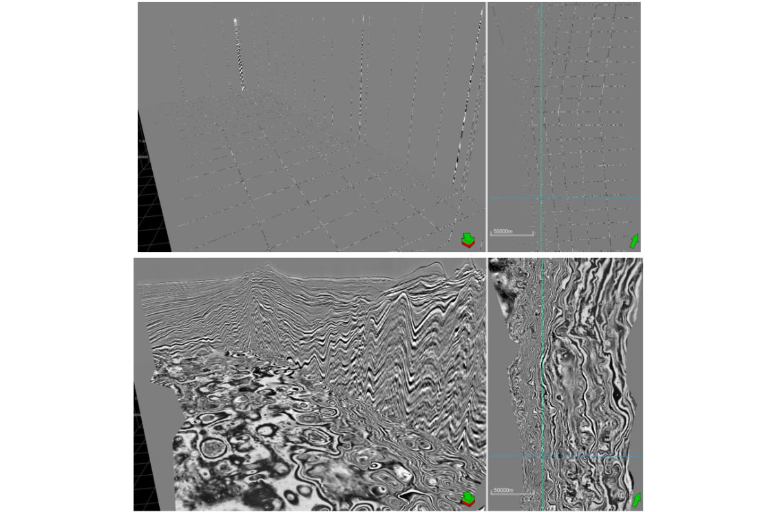
The 2D seismic data, comprising various reprocessed and recently acquired vintages, was transformed into high-resolution pseudo-3D volumes using deterministic and ML techniques. This process significantly improved resolution and definition across shallow and deep intervals, enabling more confident interpretation of structural and stratigraphic features.

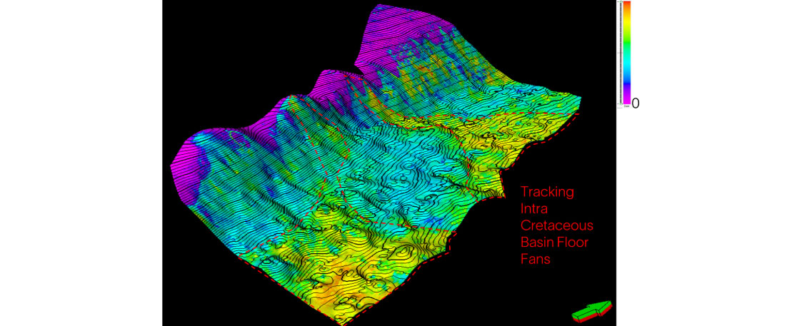
The refined 2D data, combined with horizon interpretations and calibrated using available well information, was used to construct approximate 3D structural frameworks and amplitude proxies. These pseudo-3D volumes unlock advanced interpretation tools, including volume rendering, geobody extraction, and multi-attribute overlays, enhancing regional geological insights.

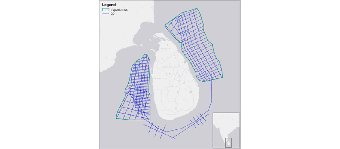
In the West Mannar and East Lanka basins, the pseudo-3D volumes were instrumental in identifying diverse play types, including both structural and stratigraphic plays. Outputs such as depth slices facilitated quick analysis of regional trends and lead screening. Past discoveries, such as Dorado and Barracuda, demonstrate the region’s potential, while ExploreCube intelligence aids in derisking stratigraphic plays using seismic attributes.

In summary, pseudo-3D imaging addresses the limitations of multi-vintage 2D seismic data, enabling the generation of seismic attribute volumes at both play and basin scales. This approach accelerates regional interpretation, supports the identification of hydrocarbon prospects, and provides a valuable tool for early-stage exploration and investment planning in the West Mannar and East Lanka basins.

East Lanka ExploreCube Intra Cretaceous RMS Amplitude Extraction.
Figure 3: East Lanka: Intra-Cretaceous root mean square (RMS) amplitude extraction using ExploreCube intelligence
Products Used