Driving exploration success via more accurate estimation of lithium resources
SLB subsurface expertise and proprietary software and modeling algorithms led to >30% increase in lithium resource estimates with a high level of confidence—critical to ongoing exploration and development efforts.
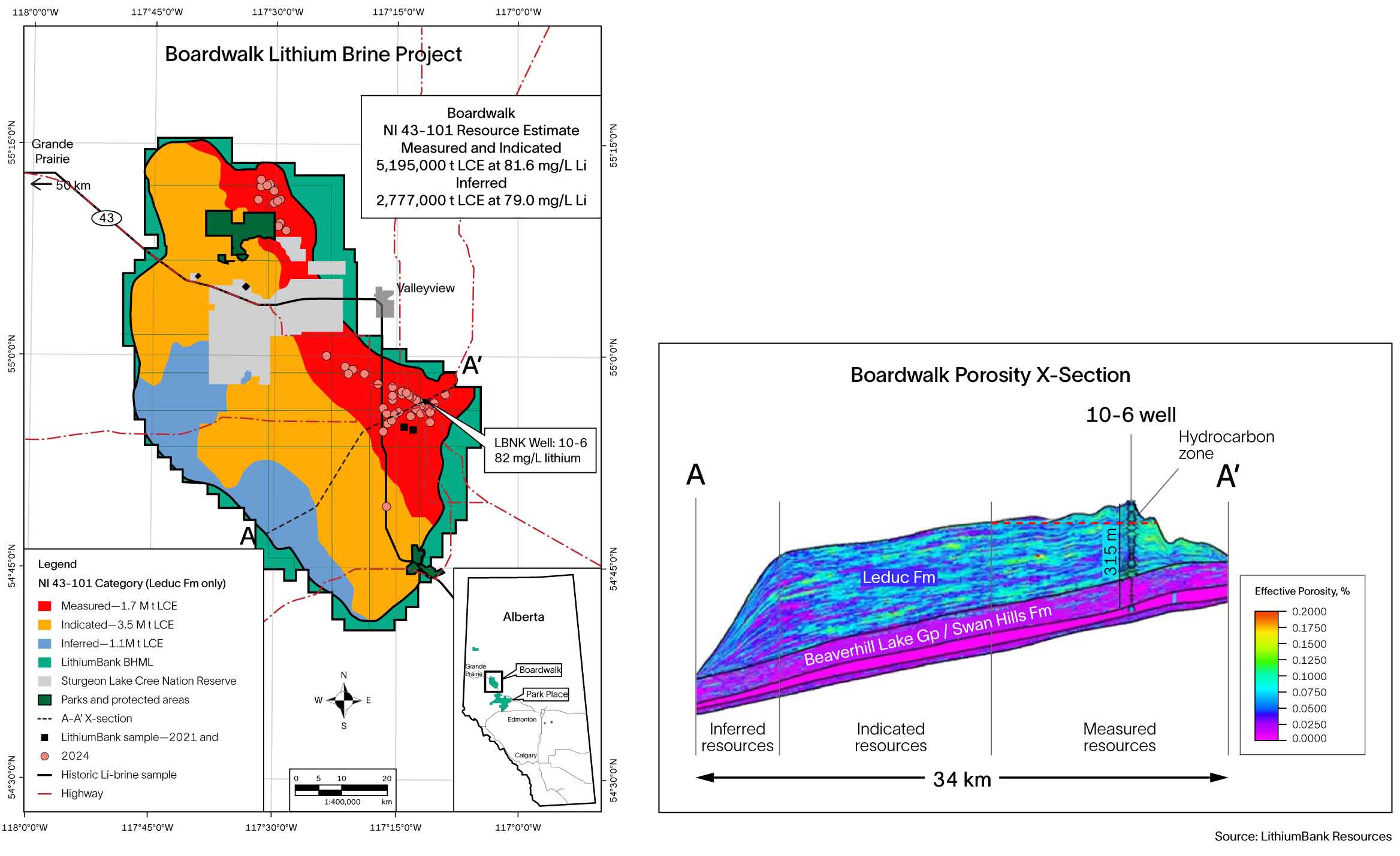
LithiumBank Resources Corp., a key player in the Western Canada’s emerging lithium sector, is actively developing brine extraction projects across the Alberta Basin. The company turned to SLB to update the resource estimates for its flagship Boardwalk Project in the region. Using its specialized expertisebuilt a higher-confidence subsurface model by incorporating lithium concentration and formation lithology data. The data was recently acquired from extending a conventional oil well by drilling a new interval into the high-prospective Leduc and Swan Hills Formations.
The initial phase of work involved construction of a static model and resource estimation. The SLB workflow for lithium resources model building included petrophysical and geophysical analysis, and reservoir characterization. The advanced model incorporated the formation facies analysis, updated porosity and permeability modeling, and interpretation and inversion of 67 km of 2D seismic data.
- Petrophysical analysis harmonized log data and computed porosity logs at each well location.
- Seismic data inversion was performed, guided and calibrated by well logs.
- The workflow also created a porosity cube for the target zone to estimate total brine volumes and resources in place.
Once new data—lithium concentration samples and logs from the reentry well—became available, the second phase began with updating the subsurface model. Petrel™ subsurface software modeling was used to re-estimate resources and classify them via sensitivity and uncertainty analysis, including connectivity estimates. The model connectivity calculations provided a preliminary assessment of the model's dynamic behavior, delivering new insights not only into the porosity distribution but also into pore connectivity and its impact on resource estimation. The SLB’s proprietary workflow steps were crucial in increasing confidence in the updated estimates and enabled reclassifying a significant amount of Leduc Formation resources from “inferred” to “measured” and “indicated.”
The SLB rigorous and comprehensive analysis resulted in a robust resource estimate that is 30% greater than previous calculations and provided LithiumBank with the confidence to advance its project. The advanced lithium resources reservoir model will also support the planning of well networks and locations in upcoming economic and engineering studies.
How can I improve the accuracy of lithium resource estimates in brine reservoirs?
Improving accuracy involves integrating multiple data types—such as seismic, well logs, and geochemical samples—into a unified subsurface model. Companies like SLB offer advanced modeling workflows that have demonstrated up to a 30% increase in resource estimates by refining porosity, permeability, and connectivity analysis.
Can I use existing oil and gas wells to explore for lithium?
Yes. Reentering oil and gas wells to access deeper formations can be a cost-effective strategy. SLB has successfully applied this approach in Western Canada, using extended intervals to gather new data for lithium modeling, reducing exploration costs and accelerating timelines.
What kind of software is used to model lithium brine reservoirs?
Subsurface modeling software like Petrel™ is commonly used to build static and dynamic models of lithium reservoirs. These tools allow integration of seismic, petrophysical, and geochemical data to estimate brine volumes and assess resource quality.