Derisking exploration and accelerating development of a lithium brine project
Using proprietary SLB lithium brine modeling software and digital workflows, SLB supported a lithium exploration and development project by delivering advanced subsurface characterization and reservoir modeling.
Pantera Lithium Limited sought to estimate in-place lithium brine resources and identify optimal drilling locations for its direct lithium extraction (DLE) project targeting the Smackover Formation in southwestern Arkansas. SLB was approached to support this objective, leveraging its decades of proven subsurface modeling expertise.
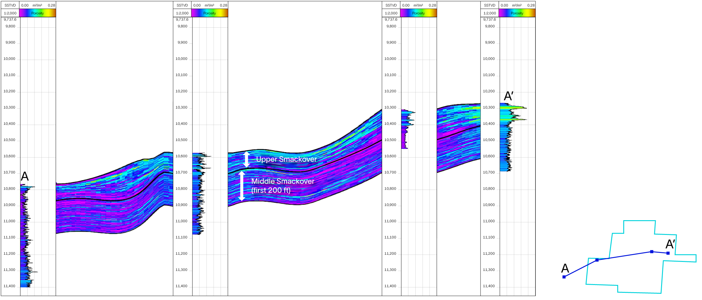
SLB applied a proprietary lithium brine resource evaluation workflow, including petrophysical analysis and 3D geological modeling, using available logs, well tops, 2D surface seismic, and gravity data to evaluate formation porosity. The petrophysical analysis harmonized the log data, assessed its confidence level, and generated porosity logs at each well location. SLB’s Petrel™ subsurface software was used to perform seismic inversion of the 2D data, guided and calibrated by well logs.
The 3D porosity model that was generated encompassed two zones: the first covered the upper Smackover Formation (Reynolds oolite), while the second extended 200 ft from the base of the former into the middle Smackover. Despite the limited coverage, it was decided to include this deeper formation because it contains brine and has the potential to provide pressure support for the upper unit—an important factor for future dynamic modeling.
The model enabled a preliminary resource estimate by using a range of lithium concentration values obtained from publicly available literature. The estimate can be refined once lithium grades are available from existing wells or new ones drilled by Pantera.
The 3D reservoir model delivered by SLB provided a detailed representation of the subsurface geology and lithium brine reservoir characteristics of Pantera’s concession, based on all available data. This model serves as a critical component in derisking and optimizing exploration planning as well as guiding the overall project development workflow.
In addition to supporting resource estimation in preparation for Pantera’s first lithium drilling campaign in the Arkansas Smackover, the model played a key role in identifying priority zones for the first well planned by the company. Most importantly, the subsurface model confirmed that the project has the potential to tap into a large, world-class lithium brine resource—comparable to those of leading operators in the state.
How can I estimate lithium brine resources if I only have limited well and seismic data?
SLB offers a proprietary lithium brine resource modeling workflow that integrates well logs, 2D seismic, gravity data, and petrophysical analysis to generate 3D porosity models—even with limited data. This enables early-stage resource estimation and helps identify high-potential zones for drilling.
What tools are available to help plan my first lithium well?
SLB’s integrated modeling approach helps identify optimal drilling locations by combining petrophysical analysis, seismic inversion, and 3D reservoir modeling. These tools guide well placement and support dynamic modeling for future production planning.
How can I reduce risk before committing to lithium drilling?
SLB’s subsurface modeling and resource estimation services provide a data-driven foundation for decision-making. By visualizing porosity distribution and estimating lithium concentrations, operators can prioritize zones with the highest potential and reduce uncertainty before drilling.