Advanced LWD Technologies Mitigate Uncertainty in Marcellus Shale | SLB

Advanced LWD Technologies Mitigate Uncertainty in Marcellus Shale

Published: 02/17/2012

Blue hero texture

Horizontal development program in Marcellus shale

Accurate placement of a horizontal well is widely accepted as the first critical step in the effective and successful completion of shale gas wells. Yet, these wells are typically steered using a single, average gamma-ray (GR) measurement, which can potentially introduce significant correlation uncertainties that result in inaccurate well placement, suboptimal completions, and ultimately, underperforming wells. This structural uncertainty can be mitigated by the integration of conventional well placement methods with borehole images.

An operator in the Marcellus shale was in the planning stages of its first horizontal development program in Pennsylvania. The operator had limited structural control in offset wells in the field, which caused a lot of uncertainty in well placement. Also, only a portion of the areas of interest were covered by existing seismic data. Because average GR could not provide an accurate structural interpretation, the operator requested assistance from Schlumberger in drilling the first two horizontal wells in its development program.

Graphic: Advanced LWD Technologies Mitigate Uncertainty in Marcellus Shale - Schlumberger LWD data identified a fault in the challenging structural environment of the two horizontal wells.
Schlumberger LWD data identified a fault in the challenging structural environment of the two horizontal wells.

Real-time LWD images and measurements to improve well placement

Schlumberger LWD technology provides real-time images, allowing geologists to pick dips while drilling and make well placement decisions by comparing the apparent dip of the formation to the borehole trajectory while drilling. Additional petrophysical measurements further enhance shale gas reservoir characterization by using spectroscopy and triple combo data to estimate the kerogen content from a core-calibrated petrophysical model.

Running geoVISION azimuthal gamma ray with imaging capability in the first lateral significantly reduced the structural uncertainty of the well placement operation by providing real-time formation dip along the length of the horizontal well. As a result, the operator requested similar support from Schlumberger on the second horizontal well.

For the second well, Schlumberger suggested running the EcoScope LWD service to obtain density and gamma-ray images in real time. By integrating all the real-time images and measurements, the Schlumberger well placement team provided a better understanding of the challenging structural environment to facilitate well placement.

Graphic: Advanced LWD Technologies Mitigate Uncertainty in Marcellus Shale - EcoScope LWD service provided density and gamma-ray images in real time.
EcoScope LWD service provided density and gamma-ray images in real time.

Structural uncertainty reduction to optimize current and future well development

Using all the available measurements and the LWD images from both horizontal wells, Schlumberger developed a 3D model of the reservoir. This information helped reduce correlation uncertainties, identified a fault, and confirmed the lateral position within the reservoir. In addition, the EcoScope measurements indicated the presence of over-matured kerogen in the area, which was considered in the design of the subsequent stimulation program.

The LWD data from these two horizontal wells have enabled the operator to better characterize the reservoir properties and structural environment to optimize future development of horizontal gas wells in this area. The 3D model of these two wells has been used to guide the remaining horizontals in the pad. In addition, the operator plans to strategically run more LWD in developing other areas.

Graphic: Advanced LWD Technologies Mitigate Uncertainty in Marcellus Shale - This image shows the interpreted fault plane across the two wells.
This image shows the interpreted fault plane across the two wells.
Location
Marcellus Shale, United States, North America, Onshore
Details

Challenge: Obtain comprehensive LWD petrophysical measurements for two horizontal gas wells in the Marcellus shale for accurate structural interpretation and reservoir characterization to be used in subsequent development

Solution: Run geoVISION imaging-while-drilling service to obtain real-time azimuthal gamma-ray imaging and EcoScope multifunction logging-while-drilling service
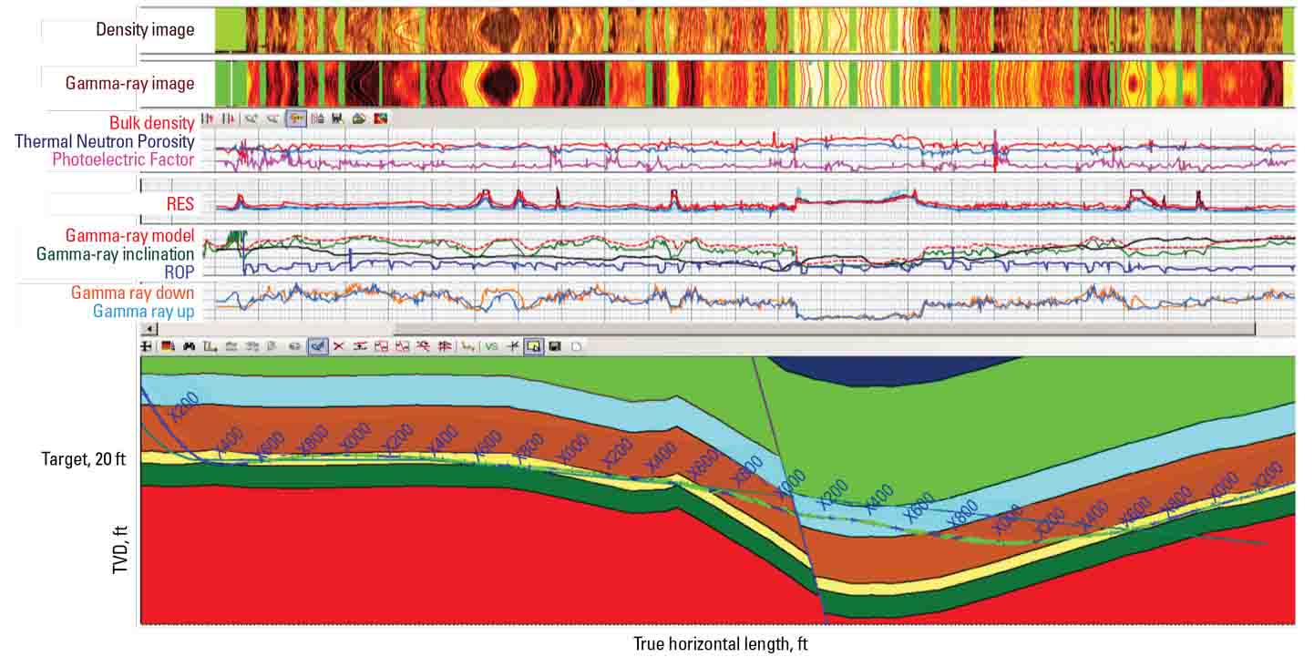
 for integration of the full suite of formation evaluation, well placement, and drilling optimization measurements to develop a 3D model of the reservoir

Results: Reduced correlation uncertainties, confirmed lateral position within the reservoir, and achieved better understanding of the reservoir properties, using all the information to design a stimulation program and optimize future development wells in the area

Products Used