Obtain resistivity, neutron porosity, azimuthal gamma ray, density, elemental capture spectroscopy, and sigma measurements and borehole imaging—all in one collar.
Apache saves USD 12.3 million
and increases expected oil recovery
by 11% offshore Australia
Challenge: Precisely geosteer six wells with 15 laterals from an offshore platform to target a thin column of oil approximately 5–10-m [16–32-ft] thick, maintaining an optimal standoff from the oil/water contact (OWC)
Results:
Obtain continuous, real-time surveying from the WellDefined™ drilling survey services in combination with a
geosteering BHA configured with GeoSphere™ reservoir mapping-while-drilling
service, PeriScope™ bed boundary mapping service, and EcoScope™ multifunction LWD
service
-
Extended laterals by a total of 4,276 m [14,029 ft], resulting in an 11% increase in expected oil recovery
-
Saved USD 12.3 million and 13 days on the drilling program
-
Set a world record for the most meterage– 33,930 m [111,319 ft]—for the WellDefined service without a single geological sidetrack
Drill 15-lateral ERD project, avoiding boundaries and nearby wells
To develop the Coniston field offshore Australia, Apache planned to drill six wells with 15 laterals from an offshore platform to target a thin column of oil. Apache needed to precisely geosteer within the 5–10-m oil column and place the well paths at an optimal standoff. Specifically, the objective was to place the well paths in the gas/oil contact (GOC) while maintaining an optimal distance from OWC. When the GOC was not present, Apache wanted to place the well paths 1–1.5-m [3.3–4.9-ft] TVD from the reservoir top. This multilateral extended-reach drilling (ERD) project also posed significant well collision risks due to lateral uncertainty. To successfully develop the thin column of oil, Apache needed highly accurate, real-time distance-to-boundary and TVD data.
Use geosteering BHA to obtain accurate downhole measurements in real time
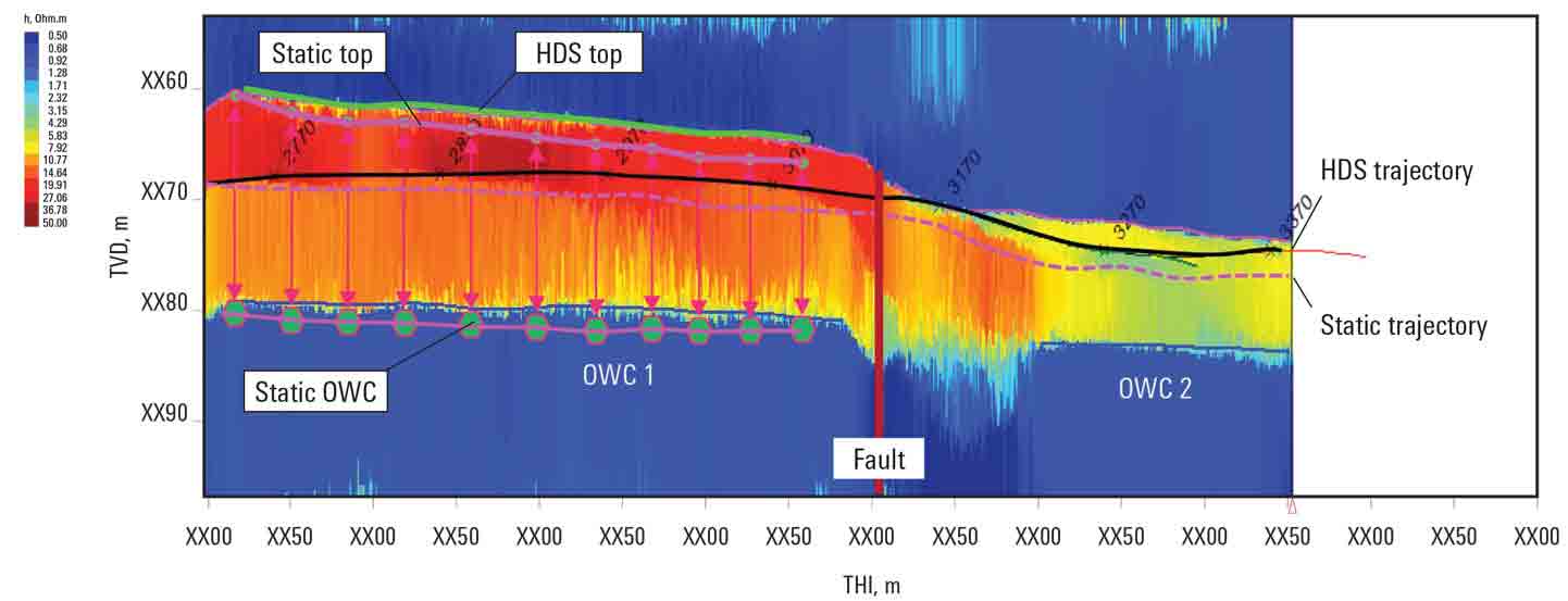
SLB recommended using a geosteering BHA in combination with WellDefined drilling survey services to determine wellbore position while drilling and at TD with respect to the predrill geological model. The geosteering BHA would include the GeoSphere reservoir mapping-while-drilling service to map the reservoir boundaries and OWC position and the PeriScope bed boundary mapping service to provide sharper vertical resolution and measurements in closer proximity to the bit.
To improve the accuracy of boundary measurements and to better quantify the changes in apparent formation dip, the WellDefined service would recalculate the data to provide a reconstructed position of detected boundary results with updated survey data every 3 m [9.8 ft]. To further confirm the position of the wellbore in relation to the GOC and to provide information for petrophysical evaluation, the EcoScope multifunction LWD service was also included in the customized BHA.

Saved USD 12.3 million and increased expected oil recovery by 11%
Over the course of the six-well, 15-lateral project, Apache extended its laterals by a total of 4,276 m and finished drilling 13 days ahead of schedule. On average, the wells were drilled 0.35 days per 1,000 m [3,280 ft] faster than anticipated, reducing operating cost by more than USD 12.3 million. Lateral by lateral, the well placement team gained a greater understanding of the reservoir structure based on highdefinition surveys (HDS) of well trajectories.
Using the geosteering BHA with high-definition surveying, Apache optimized wellpath location in relation to the reservoir fluid contacts, leading to maximized recovery of attic oil. Real TVD well placement assured Apache’s geology and geophysics team that the well was positioned accurately, which improved field development plans for subsequent wells.

