Operator needed to confirm integrity of a subsalt appraisal well
While salt structures are effective traps for oil and gas, they are also
notorious for their operational challenges. In deepwater cementing operations,
salt creep can create unusual bonding and nonuniform loading on the
casing—potentially eventually causing the tubulars to collapse. If
fractures occur in homogeneous salt sections, the resulting losses make it
difficult to evaluate the position of the fractures and their effect on TOC
placement.
Because of these challenges, the operator required TOC assurance as part
of the process of planning future development wells. While reviewing several
offset wells in an extensive exploration campaign, the operator decided to
reconfirm the condition of a section of an older appraisal well with 14-in
casing.
Conventional methods estimated TOC by analyzing only surface parameters,
which is insufficient due to the compressibility of the synthetic-base fluid
used to drill this section and the presence of losses that affected the surface
pressure parameters. In addition, the well design created a long, narrow
annulus, which acted as a choke and prevented mud from circulating back to
surface, initiating losses. Special casings with thick walls were also used for
the well construction, making it more difficult to interpret the sound
reflection behind the casing.
The operator engaged Schlumberger for Invizion Evaluation well integrity
evaluation service, which collects, integrates, analyzes, and interprets data
from multiple areas of this section of well construction, and then generates
recommendations for future sections in similar conditions.
Invizion Evaluation service exceeded conventional cement evaluation
capabilities
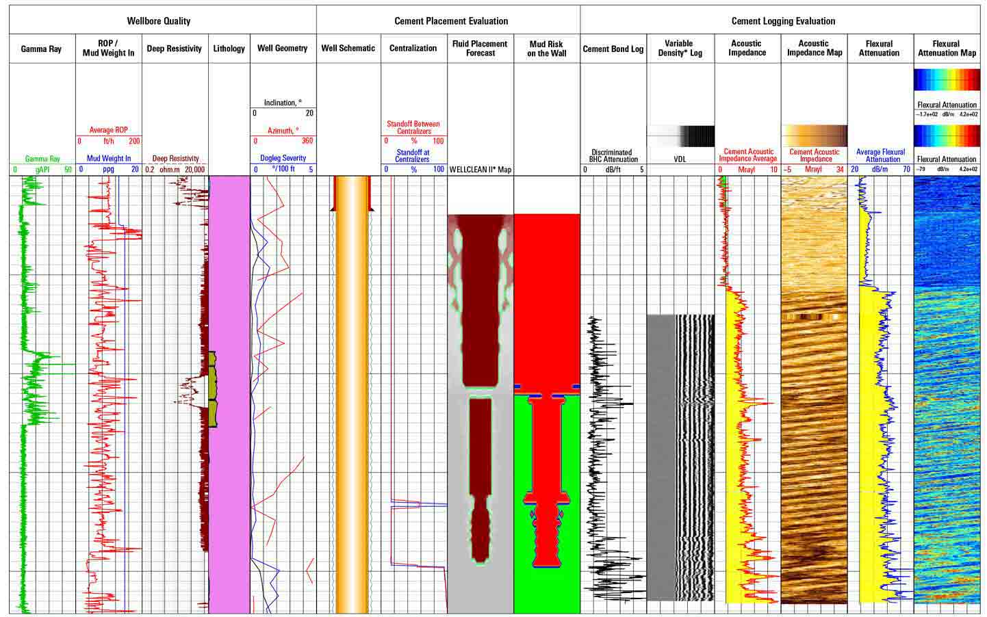
Previous job data showed the well had been cemented with losses through
a clean salt section to a measured depth of 19,923 ft [6,073 m]. The TOC was
initially estimated to be at 18,640 ft [5,681 m].
Schlumberger recreated the lithology profile based on available openhole
data and identified the position of losses in the open hole, and then conducted
cross-domain data evaluation using openhole, cement placement, and cased hole
logs. Advances in cementing simulations helped the team account for the
synthetic-base mud compressibility effect, losses, and flat fluid interfaces in
the placement simulator. The result of the new analysis showed that
contaminated cement was placed up to 16,160 ft, with the partial losses at
17,200 ft—correlating with the well's position in the salt body.
Operator improved cementing practices for future field wells
The Invizion Evaluation service helped the operator accurately confirm
the TOC and understand the true cause of losses after conventional analysis
could not. After the evaluation, Schlumberger provided detailed
recommendations, including analyzing openhole data and identifying the loss
zone prior to cementing to aid in evaluation—enabling the operator to
develop a lost circulation strategy, improve job performance, and enhance
cement evaluation for future development wells in the project.