Energean uses PeriScope HD and geoVISION Services to Drill Precisely Across Caprock Crest, Prinos North Field
Published: 06/22/2019

Energean uses PeriScope HD and geoVISION Services to Drill Precisely Across Caprock Crest, Prinos North Field
Published: 06/22/2019
“Energean is happy with the PeriScopeHD service performance.”
Paschalia Kiomourtzi, Prinos Exploration Manager Energean Oil & Gas PLC
Land the well at 90° inclination while overcoming lithological uncertainties
The Prinos North Field has been developed by Energean Oil & Gas PLC as a satellite field of the main Prinos Field since 1996. Prinos North Field is a four-way dip closed structure with hydrocarbons trapped in a Miocene turbiditic sandstone reservoir. It is separated from the main Prinos Field by a listric fault and it is located on the footwall side. Due to this fault, the geological formations of the footwall area, including the evaporitic sequence and the Prinos North structure, exhibit huge lateral thickness changes, missing stratigraphic sections, and pinchouts.
Due to these uncertainties, a detailed prejob analysis was performed to determine the landing and drilling strategy. Based on seismic data, the uncertainty in the position of the reservoir top was ±10 m. Additional geological uncertainties were represented by the presence of formation thickness changes and faulting.
To prepare for a worst-case scenario, Energean planned a tangent section that would enable the reservoir top to be reached as early as possible while still landing at 90° inclination, 7 m below the reservoir top using the maximum dogleg severity (DLS) limit allowed.
The well objective was to place the 7-in liner inside the caprock with a specific inclination. The inclination had to be precise enough to enable optimizing the landing and the drain inside the reservoir, penetrating the crest, keeping the trajectory above the depth restrictions of the offset wells, and providing adequate well length into the 6-in openhole section.
Determine landing strategy with the PeriScope HD service
The well plan involved drilling parallel to the structural dip. According to the plan, the geoVISION service was used in the 8.5-in section to warn the driller of lithological changes. At this time, the landing section of the caprock formation was found to be 12 m deeper than expected.
The PeriScope HD service inversion helped to estimate the formation dip of the caprock top, define the lower main salt thickness above the caprock, and determine the strategy for landing inside the reservoir. When there is no borehole image, the estimation of the formation dip is vital for the definition of the correct incident angle and a successful landing.

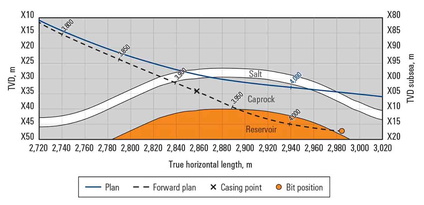
The 8 1/2-in section TD was drilled as planned, ending roughly 5-m TVD below the top.
In the 6-in horizontal section, the PeriScope HD service was used stand-alone to detect the reservoir top early, map possible markers to be used as geosteering references, and ultimately estimate the formation dip for the model update. The marker above the reservoir top was identified at approximately 45-m MD from a 3-m distance, enabling a dip estimation of about 0° in the direction of drilling.
After a successful landing inside the reservoir at about 90°, the wellbore was kept at a minimum distance of 3 m from the reservoir top, until the production objective of at least 350 m of exposure inside the reservoir was achieved. Toward TD, wellbore inclination was increased to intersect the caprock and gain a structural control point at TD.
Landed the well without sidetracking
Well PNA-H4 was successfully landed in the reservoir, and the horizontal section was drilled to 410-m MD within the pay zone because the target was larger than the planned 350-m MD. This extended exposure significantly increased the productivity of the well. Despite a low resistivity contrast of 2–5 ohm.m, the PeriScope HD service proved effective. Using this real-time geosteering service avoided the need to drill a pilot hole or sidetracks, resulting in an optimal placement within a complex geological environment.
This solution enabled the team to expose the reservoir attic oil, increase the productivity of the field, and avoid any additional completion cost.
Challenge:
- Land and place a 7-in liner inside the caprock without penetrating the reservoir, despite the high seismic uncertainty and limited lateral extension of the crest.
- Expose at least 350 m of the reservoir in the 6-in openhole section while dealing with formation thickness, faulting, formation changes, limited offset well data, and low resistivity contrast.
- Avoid sidetracking.
Solution: Use the PeriScope HD multilayer bed boundary detection service and the geoVISION imaging-while-drilling service to map the reservoir, define structural dips, and provide an early warning of lithological changes.
Results:
- Achieved a net-to-gross (NTG) ratio of 100%.
- Avoided sidetracking.
- Successfully mapped the reservoir top.