To find promising exploration targets, experts deploy various technologies to quantify the likelihood that all these conditions are met. Exploration integrates the efforts of all types of geoscientists—geologists, geophysicists, petrophysicists, paleontologists and geochemists—into a coherent evaluation of how the petroleum systems in a basin have evolved.
The exploration team interprets data from a multitude of physical measurements made at a wide range of scales. Geologists study outcrops to determine the types of rocks that may be present at depth in the basin. They review aerial photography and satellite imagery to find folds, faults and seeps. From well logs, geologists can characterize the nature of subsurface formations and correlate formations from one well to another, creating maps and 3D models of sedimentary basins. Cores, or samples of rocks taken from boreholes, provide ground truth readings on a fine scale.
Geophysicists interpret seismic, magnetic and gravimetric surveys preformed on land and at sea to identify tapping structures and potential hydrocarbon indicators. By correlating seismic data with information from wells, geophysicists can determine the depth of a prospective structure. Petrophysicists analyze well log data to determine the volume and types of sediments and fluids present and the ability of the rock to produce hydrocarbons. Paleontologists examine fossils to assign ages and depositional environments to rock sequences. Geochemists assess the potential of the source rock to generate petroleum.
The results of these studies can be put into computer simulations called petroleum system models that determine potential accumulation locations, volume and content, along with information that will be used to judge their chances of success.
Typically, exploration geologists focus on a particular region to develop a play, or collection of potential petroleum prospects with similar geology. They use the characteristics of previous discoveries to predict the occurrence of similar but undiscovered accumulations. After collecting and interpreting the available data, geologists identity leads, or features of interest, on which to focus additional data-collection and interpretation efforts. Leads that have been investigated and found to be potential traps for hydrocarbons are designated as prospects.
Once the prospects in a region have been identified, exploration experts rank them according to risk and reward. To Optimize their assets, oil and gas exploration and production companies strive to maintain a balanced portfolio of projects with outcomes ranging from high risk, high reward to lower risk and reward.
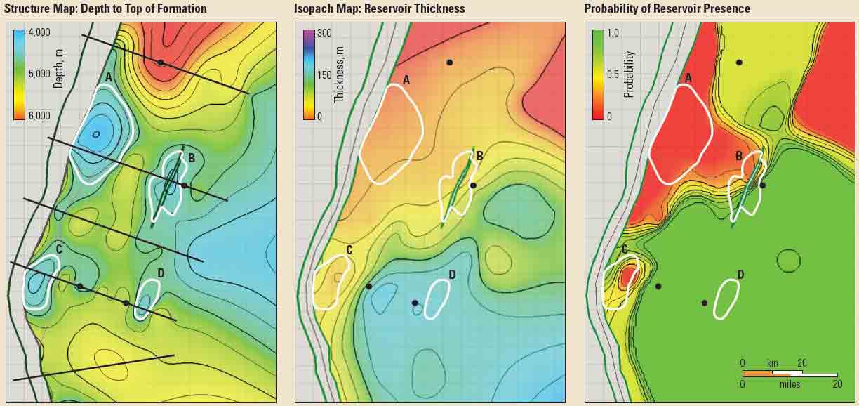
A key challenge is to understand the range of potential outcomes in a prospect, since there are rarely sufficient data for a firm estimate of how much oil or gas might be in an undrilled structure. Geologists calculate a range of volumes of hydrocarbon reserves by combining information on the areal extent and thickness of prospective reservoir rock, the expected porosity of that rock and the types of hydrocarbon present in the trap (Figure 2) . Detailed 3D seismic surveys can provide images of the subsurface to improve these estimates, but only by drilling a well can an exploration company confirm a structure's content.