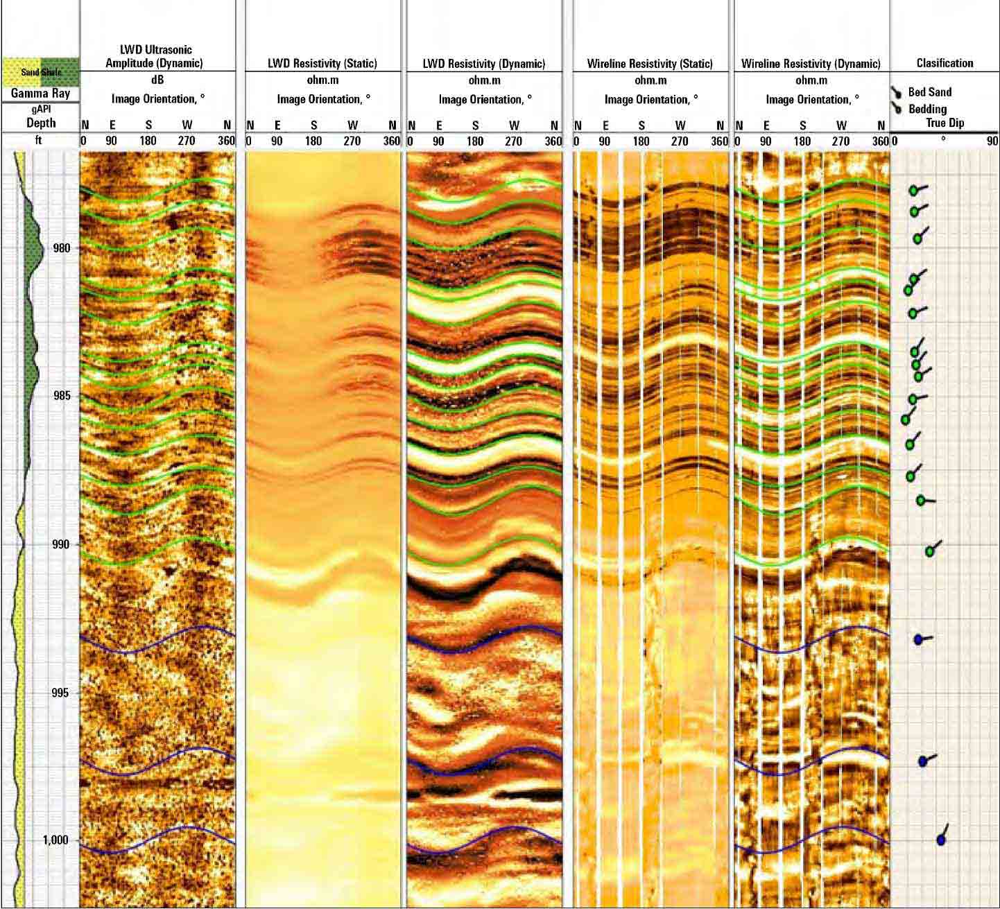
Operator Uses Dual-Physics Imaging to Identify Structural Detail While Drilling with OBM | SLB

Operator Uses Dual-Physics Imaging to Identify Structural Detail While Drilling with OBM

Published: 08/30/2019

Blue hero texture
Subsurface detailing: TerraSphere service images enable sedimentological interpretation and provides information on borehole condition.

Operator challenge

Miocene reservoirs of deepwater Gulf of Mexico (GOM) are often complicated by steep dips close to salt domes and the presence of potential fluid conduits due to faults or fractures. Though essential for sedimentological and structural interpretation, core evaluation is expensive and may not be feasible for the deepwater development projects.

The traditional option

To accurately determine the depositional facies, acquiring high-resolution borehole images from wireline logging was an option in reservoir evaluation workflows to complement seismic imaging for the reservoir description. But in mass-transport complexes where borehole degradation often poses risks for openhole wireline logging, the operator was looking for an alternative while-drilling solution without compromising on image quality.

What Schlumberger recommended

Schlumberger recommended its new TerraSphere service, the industry’s first logging-while-drilling dual-physics imager for all OBM.

It incorporates electromagnetic and ultrasonic measurements that enable high-resolution, multiple borehole images in nonconductive mud. This provides enhanced details for reservoir interpretation that uncover subtle variations in the subsurface.

What TerraSphere service achieved

Side-by-side comparison with wireline logs in the same well showed that TerraSphere service images were significantly higher resolution in the OBM environment than any images provided by previous-generation LWD imagers. This resolution enabled recognition of thin laminated beds, bedding deformation, facies variations, and onset of drilling-induced features.

Location
Gulf of Mexico, United States, North America, Offshore
Details

An operator used wireline imaging for reservoir geology to benchmark TerraSphere high-definition dual-imaging-while-drilling service, which delivers real-time high-resolution imaging while drilling with oil-based muds (OBM)—previously unavailable via earlier-generation LWD imagers.

Products Used