Major operator drills Asia’s first well section delivered with autonomous geosteering, setting a new benchmark

Autonomous geosteering sets new operational standard for Malaysia
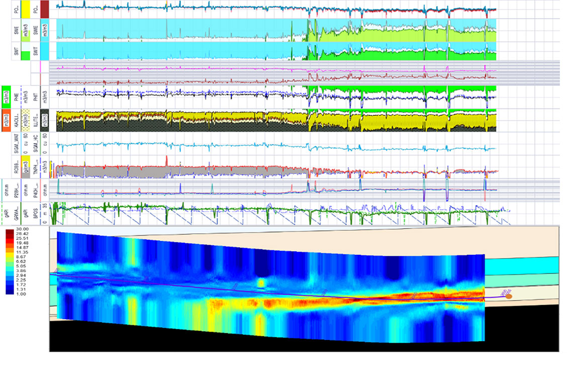
Asia’s first fully autonomous geosteering operation in offshore Malaysia successfully optimized well placement in a challenging sand reservoir, utilizing advanced AI and real-time mapping technologies.
The autonomous system maintained reservoir contact 3 m above the reservoir base with minimal human intervention, delivering more efficient operations, enhanced well productivity, and setting a new benchmark for automated well construction in the region.
Leveraging AI automation to improve well placement accuracy
Offshore Malaysian fields face complex subsurface challenges such as structural uncertainties, well control concerns, intricate sand continuity, and uncertain fluid contacts.
During this project, the operator sought an innovative approach to maximize recovery from a thin, variably dipping sand reservoir, while minimizing drilling risk and improving wellbore placement accuracy.
Autonomous geosteering workflow maximizes reservoir exposure
To address these issues, the operator selected to deploy a fully autonomous geosteering system, leveraging the AI capabilities of the Subsurface Advisor™ intelligent subsurface drilling solution and the Neuro™ Autonomous Geosteering solution.
The integrated product suite aimed to automate real-time subsurface data interpretation and well trajectory adjustments, allowing precise navigation through uncertain geology, and enabling operational geologists to shift focus to higher-value oversight tasks, improving decision quality and production outcomes.
Leveraging the real-time reservoir mapping and automated inversion in the GeoSphere HD™ high-definition reservoir mapping-while-drilling service, and the automated boundary picking available in the Subsurface Advisor solution, the operator managed to continuously map the thin sand body. The project team was able to steer the wellbore within 3 m above the reservoir base throughout the lateral section.
The advanced AI system dynamically updated geological models and executed four autonomous trajectory changes—each with sub-20-second decision cycles—demonstrating high operational agility and alignment with expert geologist interpretation.
The PowerDrive Orbit™ precise and versatile rotary steerable system and EcoScope™ multifunction logging-while-drilling service ensured directional control, high-fidelity formation evaluation, and uninterrupted data for the autonomous engine. Utilizing the TruLink™ definitive dynamic survey-while-drilling service enabled robust telemetry and survey feedback for the project team.
By running these technologies in autonomous mode, the operator drilled efficiently and accurately within the clean target sand, improved their well placement, and maximized productive reservoir exposure—all while freeing up bandwidth to focus on higher value oversight tasks.
Related products
-

Autonomous Directional Drilling
Enhanced technologies to improve well constructionLeveraging autonomy to build wells with efficiency and consistency, regardless of the rig, field, or trajectory.
-

Autonomous Geosteering
Achieve optimal reservoir placement and increased productionLeveraging advanced inversions in connected workflows.
-
EcoScope
Multifunction logging-while-drilling serviceObtain resistivity, neutron porosity, azimuthal gamma ray, density, elemental capture spectroscopy, and sigma measurements and borehole imaging—all in one collar.
-

GeoSphere 360
3D reservoir mapping-while-drilling-servicesNow you can drill with real-time insights on fluid volumes, bodies, faults, and lithology—at reservoir scale.
-

PowerDrive Orbit
Rotary steerable systemAchieve precise wellbore positioning on any rig type worldwide.
-
Subsurface Advisor
Intelligent subsurface drilling solutionA cloud native solution that unifies subsurface workflows and delivers real time automated insights for faster decisions.